









KŌLOGY · Màn hình & chức năng
Drive with KŌLOGY navigation
The map follows the car, turns with the streets and shows the next turn.
Bài viết này chưa được dịch sang ngôn ngữ của bạn: đang hiển thị bản English.
Trong trang này
While navigating
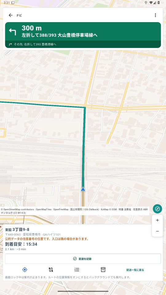
- On the delivery, tap Navigate. The map locks onto the car (blue arrow), turns with your heading and tilts, like Google Maps.
- The green bar at the top shows the next maneuver: arrow, distance and street name. The dark strip under it shows the one after.
- The part of the route already driven turns grey; what is left stays green.
- At the bottom: destination address (postal code, town, chome-ban-go highlighted, building), arrival time, distance and minutes left.
- Zoom changes by itself: closer when slow and before turns, wider on main roads.
Buttons
- Re-center appears when you drag the map (dragging pauses following so you can explore): tap it to follow the car again and resume automatic zoom. The button sits above the map credits strip.
- Compass (N): keeps north at the top and remembers that choice while you drive. To make the map turn with the car again, turn it on in the ⋮ menu.
- Map credits strip (ⓘ): tap it to see the full sources and licences (OpenStreetMap, OpenMapTiles, GSI, MOJ/ABR).
- Numbered list: every OSRM maneuver.
- Menu ⋮: voice, night mode, map turns with the car (off = north up), 3D view, auto zoom, map engine, open in Google Maps.
Off the route? It recalculates in a few seconds (with a sound). The screen stays on while navigating. With route GPS on, voice continues with the screen locked.