









KŌLOGY · Screens & features
Drive with KŌLOGY navigation
The map follows the car, turns with the streets and shows the next turn.
On this page
While navigating
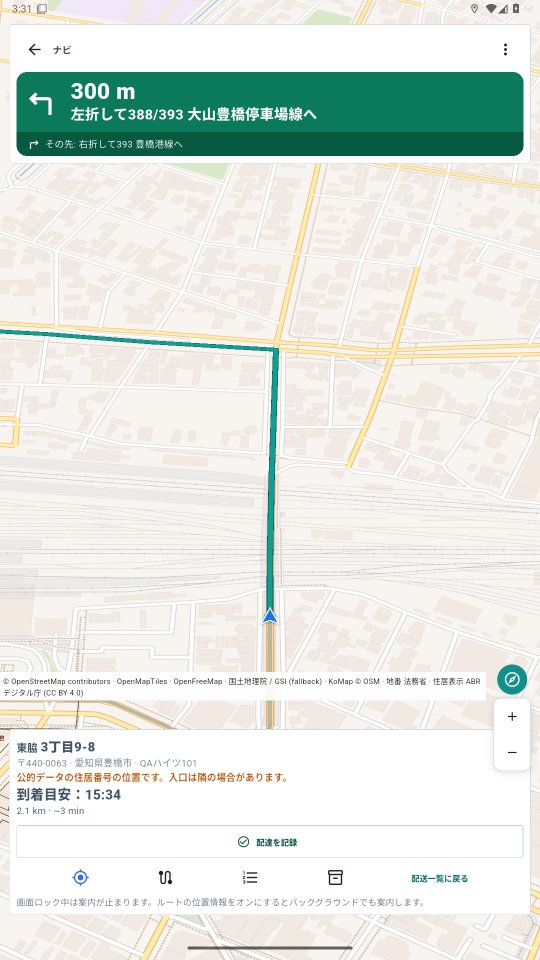
- On the delivery, tap Navigate. The map locks onto the car (blue arrow), turns with your heading and tilts, like Google Maps.
- The green bar at the top shows the next maneuver: arrow, distance and street name. The dark strip under it shows the one after.
- The part of the route already driven turns grey; what is left stays green.
- At the bottom: destination address (postal code, town, chome-ban-go highlighted, building), arrival time, distance and minutes left.
- Zoom changes by itself: closer when slow and before turns, wider on main roads.
Buttons
- Re-center appears when you drag the map (dragging pauses following so you can explore): tap it to follow the car again and resume automatic zoom. The button sits above the map credits strip.
- Compass (N): keeps north at the top and remembers that choice while you drive. To make the map turn with the car again, turn it on in the ⋮ menu.
- Map credits strip (ⓘ): tap it to see the full sources and licences (OpenStreetMap, OpenMapTiles, GSI, MOJ/ABR).
- Numbered list: every OSRM maneuver.
- Menu ⋮: voice, night mode, map turns with the car (off = north up), 3D view, auto zoom, map engine, open in Google Maps.
Off the route? It recalculates in a few seconds (with a sound). The screen stays on while navigating. With route GPS on, voice continues with the screen locked.